Research
Our research applies satellite observations and computational modelling to understand how dams, reservoirs, and river regulation shape water availability. We develop openly-available tools and datasets designed to work in data-sparse regions where in-situ monitoring is limited.
Use the search bar below to filter publications.
All Publications
2025
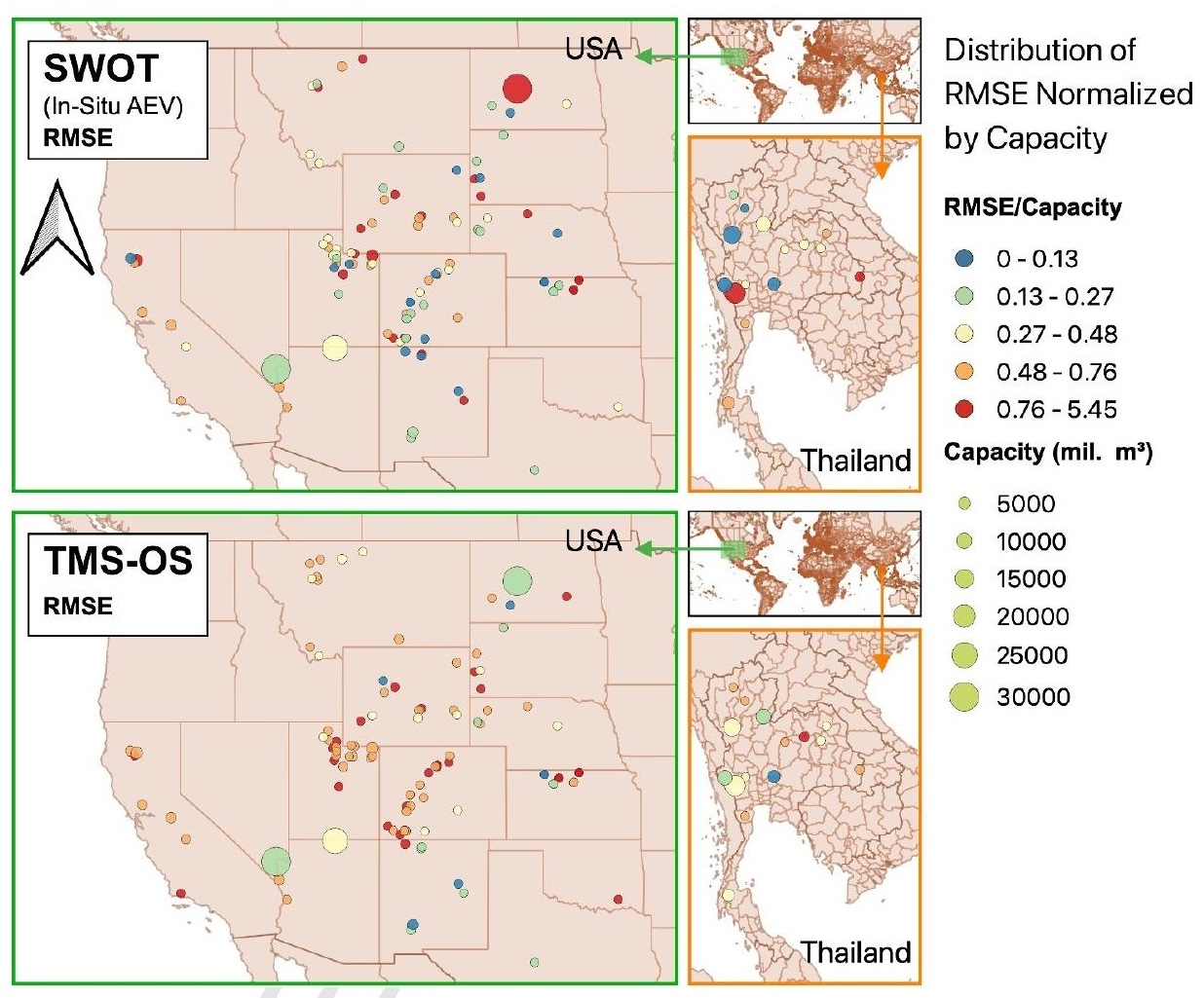
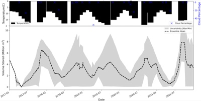
Multi‐Satellite Tracking of Surface Water Storage Change in the Era of Surface Water and Ocean Topography (SWOT) Satellite Mission
Earth and Space Science
·
01 Jun 2025
·
doi:10.1029/2024EA004178
Evaluates SWOT’s capability to estimate reservoir storage dynamics. SWOT shows near-order-of-magnitude improvement in elevation RMSE over pre-SWOT approaches.
Reservoir assessment tool (RAT): a Python package for monitoring the dynamic state of reservoirs and analyzing dam operations
Digital Water
·
11 Apr 2025
·
doi:10.1080/28375807.2025.2487762
RAT packaged as a conda-installable Python library with a CLI and hosted documentation at ratdocs.io.
Forecast-Informed Reservoir Operations within a Satellite-Based Framework for Mountainous and High-Precipitation Regions: Case of the 2018 Kerala Floods
Journal of Hydrologic Engineering
·
01 Apr 2025
·
doi:10.1061/JHYEFF.HEENG-6276
Explores forecast-informed reservoir operations in mountainous, ungauged basins using GEFS precipitation forecasts and the fully satellite-based RAT framework, with application to the 2018 Kerala floods.
2024
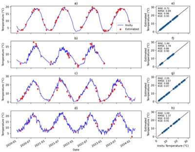
Reconstruction of the Hydro‐Thermal Behavior of Regulated River Networks of the Columbia River Basin Using Satellite Remote Sensing and Data‐Driven Techniques
Earth's Future
·
01 Oct 2024
·
doi:10.1029/2024EF004815
Reconstructs 42-year surface-water-temperature records for the Columbia River Basin using Landsat thermal infrared and a Random Forest model, revealing long-term downstream warming.
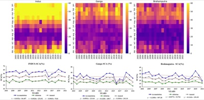
Remote sensing of snow cover dynamics and climate implications in the Indus, Ganga, and Brahmaputra river basins
Climate Dynamics
·
17 Jun 2024
·
doi:10.1007/s00382-024-07280-5
MODIS-based analysis of annual and seasonal snow-cover area variability in the Indus, Ganga, and Brahmaputra basins from 2003 to 2021, correlated with ERA5 temperature and precipitation.
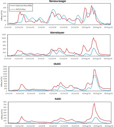
Satellite-based tracking of reservoir operations for flood management during the 2018 extreme weather event in Kerala, India
Remote Sensing of Environment
·
01 Jun 2024
·
doi:10.1016/j.rse.2024.114149
RAT 3.0 applied to monitor 19 reservoirs during the 2018 Kerala floods, demonstrating satellite-based tracking of reservoir state in a mountainous, high-precipitation, data-sparse environment.
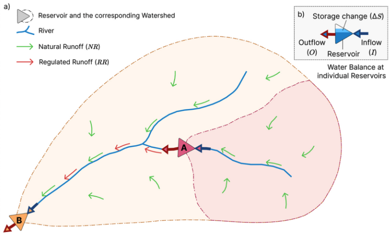
ResORR: A globally scalable and satellite data-driven algorithm for river flow regulation due to reservoir operations
Environmental Modelling & Software
·
01 May 2024
·
doi:10.1016/j.envsoft.2024.106026
ResORR: a globally scalable satellite-driven algorithm for modelling regulated river flow due to upstream reservoir operations, validated on the Cumberland River Basin (USA).
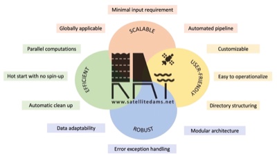
Reservoir Assessment Tool version 3.0: a scalable and user-friendly software platform to mobilize the global water management community
Geoscientific Model Development
·
23 Apr 2024
·
doi:10.5194/gmd-17-3137-2024
RAT 3.0: a scalable, user-friendly, open-source software platform for satellite-based monitoring of reservoir storage and regulated river flow, with improved hydrological modelling and multi-sensor remote sensing integration.
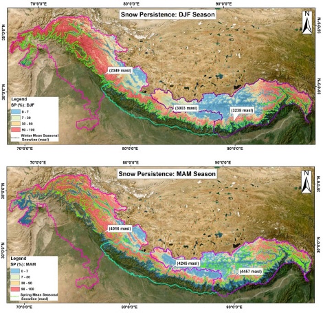
Assessing snow cover patterns in the Indus-Ganga-Brahmaputra River Basins of the Hindu Kush Himalayas using snow persistence and snow line as metrics
Environmental Challenges
·
01 Jan 2024
·
doi:10.1016/j.envc.2023.100834
Uses snow persistence and the RSLE approach to assess snow-cover patterns in the Upper Indus-Ganga-Brahmaputra basins over 2003-2021.
2023
Understanding Volume Estimation Uncertainty of Lakes and Wetlands Using Satellites and Citizen Science
IEEE Journal of Selected Topics in Applied Earth Observations and Remote Sensing
·
01 Jan 2023
·
doi:10.1109/JSTARS.2023.3250354
2022
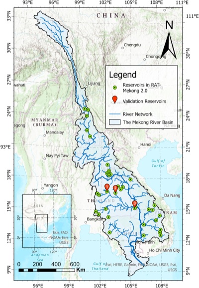
Reservoir Assessment Tool 2.0: Stakeholder driven improvements to satellite remote sensing based reservoir monitoring
Environmental Modelling & Software
·
01 Nov 2022
·
doi:10.1016/j.envsoft.2022.105533
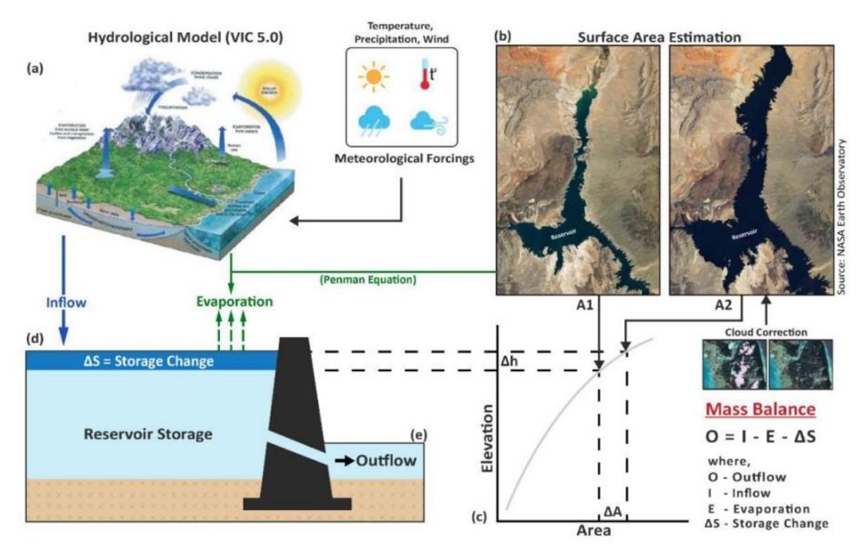
RAT 2.0 introduces a multi-sensor (optical + SAR) reservoir area estimation technique at 1-5 day temporal resolution (TMS-OS) and improved hydrological model calibration, developed with stakeholder feedback from the Mekong River Commission.
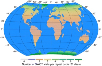
Building User‐Readiness for Satellite Earth Observing Missions: The Case of the Surface Water and Ocean Topography (SWOT) Mission
AGU Advances
·
29 Oct 2022
·
doi:10.1029/2022AV000680
Documents the NASA SWOT Early Adopter Program as a model for proactive, pre-launch user-readiness building for satellite Earth observing missions.
2019
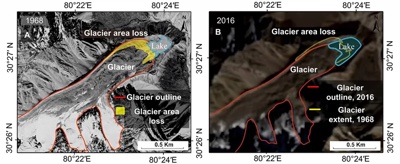
Glacier-Surface Velocity Derived Ice Volume and Retreat Assessment in the Dhauliganga Basin, Central Himalaya – A Remote Sensing and Modeling Based Approach
Frontiers in Earth Science
·
14 May 2019
·
doi:10.3389/feart.2019.00105
Estimates glacier ice volume and retreat in the Dhauliganga Basin (Central Himalaya) using surface-velocity-based modelling and historical Landsat imagery.
Conference Proceedings
2024
Hidden Sediments, Lost Capacity: How Swiftly Are Global Reservoirs Depleting?
AGU 24 Fall Meeting
·
01 Dec 2024
Toward Integrative Flood and Drought Management Services for Lower Mekong
AGU 24 Fall Meeting
·
01 Dec 2024
2023
Monitoring and Predicting Reservoir Driven River Regulation from Space
AGU Fall Meeting
·
01 Dec 2023
Reconstruction of the Hydro-Thermal History of Regulated River Networks Using Satellite Remote Sensing and Data-driven Techniques
AGU 23 Fall Meeting
·
01 Dec 2023
Reservoir Assessment Tool 2.0: Stakeholder-driven Improvements to Satellite Remote Sensing-Based Monitoring of Reservoirs
American Meteorological Society Annual Meeting – Roger Pielke Symposium
·
01 Jan 2023
2022
Monitoring Reservoir Operations of the Mekong River from Space – A Self-Correcting Multi-Sensor Approach
AWRA Annual Water Resources Conference
·
01 Nov 2022